

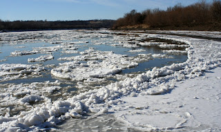
Took a nice walk down the riverside. I was interested in beachcombing- my mother seemed to enjoy all of the ice more! Last week's Arctic temperatures produced some major ice up north- much of which has been broken apart and sent downstream by warmer weekend temps and dropping river levels. In parkville however, most of the ice seemed intact! We skated upstream- the ice was very solid for several feet from the shore. New ice-bridges allowed us to avoid the mud and walk across many hundreds of feet of the Missouri River! We shuffled back and forth between the exposed dikes and the island-sandbars that they hid. Thick ice coated even the largest pools between dikes, but crossing these deep pools was too risky for us.
 In many places the ice was solid all of the way down- the rocks and mud at the bottom of the slowest channels were made clearly visible by the ice.
  Other things were under the ice too- shiny and colourful things and things that moved in an odd, swimming manner. These swimming things, however, were not swimming- they were flowing and they multiplied and divided like an erie shape-shifter. They came in all sorts of colors, shapes and size, though none stayed the same for very long, and they fled when chased- often dividing, sprawling and spreading when they ran.
It took a couple of glances, but the creepy things were bubbles- big, silvery masses of air trapped several inches beneath me. I ran a large one into a crack in the ice, but it did not burst like I'd hoped; instead the bubble slipped from under the ice and into the atmosphere. 
Big 'ice lilies' sped past us- miniature slushy icebergs. many are round with raised edges and it wasn't until I watched them move today that I figured out why..
The ice that we stood on was 4-6 inches thick. It will shatter in place if the water level rises or falls dramatically before the ice melts. The shatters, some many feet long, are rigid and solid when the enter the flow of the river.
As the sheets float, they soften due to slow melting in the water and often accumulate the smaller soft bits of ice when they overtake them. The sheets are floated into each other and the frozen shore and jagged edges are ground to more rounded shapes. The "sawdust" that is made when the edges are polished is often pushed atop the iceberg.
 The same thing happens to the ice that remains attached to the shore- it is ground and polished into shapes that accommodate the flow of the water and the excess ice is piled on the waterline. It is very cool to watch- the process is soo slow and reminds me of something like plate-tectonics. I image the ice that is pushed up to be mountains and the longest shore-side ones resemble a range the best.
 The constant grinding, crushing, crumbling, shaving, rubbing, mixing sound produced by hundreds of collisions at any given time comes to sound a little more peaceful from shore. A chemical reaction was the first thing that came to mind; like when you add baking soda to lava-coloured vinegar to get a volcano eruption- that sort of soft, fizzing sound. When coupled with the sight of the river here, the sound is relaxing and allows a sense of tranquility that is not often had so close to home- almost blissful.
The concept, too, is inspiring and awesome.
 We found some cool stuff, but for the first part of our trip, most of the agates and fossils were frozen to the ground. Mom found a very cool Bison tooth- fossilized and turned blue by time and polished by the river. I got the remains of the skull- it is busted up, but still very cool-looking!
 -A pair of ancient antlers, too! My first thought was elk- We've found elk-parts before- but I think it may just be a very large deer. The base of the antlers are more that 1.5inches in diameter! I wonder where it started? Parkville? Leavenworth? Rulo? Maybe not even on the Missouri; Any of our beautiful artifacts could have come from somewhere up a Tributary! The missouri river Watershed drains water and bones from 10 states before it hits parkville- As far as the Idaho/Montana border!
A melting route made for some challenging (and exciting) moments on our adventure back! What Fun! Anyone wanting directions to the sandbars here should e-mail me; their treasures can be collected when the river is under 7ft (see USGS realtime water data for this measurement- link at bottom of blog "USGS MO R @ KC") Hope you get out there while the lilies are still about! 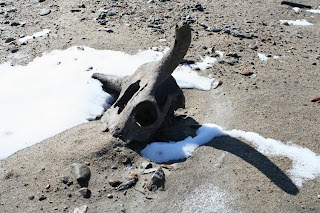

No comments:
Post a Comment