 Mountainmen and Fur traders, as well as many Osage Indians traveled for days to reach Fort Osage- often floating of hiking the river. It was in 1804 that the area's first non-indian settler, Pierre Chouteau of the Chouteau Fur Trading family helped take Osage chiefs to meet President Jefferson. The President promised to build the Natives a trading post which, thanks to Chouteau, was erected in '08 and named Fort Clark, after William Clark, who noted the area in 1804:
 "high commanding position, more than 70 feet above high-water mark, and overlooking the river, which is here but of little depth"
Clark was also the head of Indian Affairs when the Fort was named. The Fort was one of the first U.S. military installations in the Louisiana Purchase and served as a stopover and trading post for river-travelers and the Osage indians. FOr the military, the post meant regulating trade and was a method of establishing peace (and control) with the Osage people.
The fort was given the name Fort Osage and a gentlemen named George Sibley succeeded Chouteau as the Osage Indian agent. George mingled with traders and visitors alike and made for a welcoming host of Fort Osage with his 16 year-old wife... Frequents knew the Fort by the name Fort Sibley.
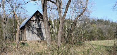
the year 1821 marked the arrival of J McCoy, founder of Westport on the Santa Fe, and The admission of the State of Missouri to the Union. A year later, the Fort Osage operation was formally ended by the military, and used as a storage area for posts in Leavenworth and along the Osage River near Nevada, MO (Fort Scott). Cut Wood from the post was salvaged by the early local residents until only the Foundation stood at the end of the decade. George Continued supporting the small community that he helped raise with favors and a small trading post. Independence and McCoy's "Westport" went on to compete with each other (and later St. Joe and LEavenworth) for the area's trade dominance. McCoy's trading post dominated because of it's strategic location only four-miles south of the missouri at it's confluence with the Kaw- then known as 'the Great Bend." The GReat Bend marked the eastern-most point of the river's southern stretch. This allowed merchandise to be floated almost 20-miles upstream (west) of the existing western stop on the Santa-Fe Trail- Independence. Travelers began skipping the established trading posts to take advantage of Westport's 20-mile advantage and McCoy's business founded modern-day Kansas City. Sibley passed and the community which he created claimed township under the name Sibley, Missouri. It remained a relatively quiet place as the Civil war ripped border towns like Westport, Leavenworth and Lawrence; Jackson County remained almost entirely pro-south until the Union ended Confederate military operations of the area in '64 (The Battle of Westport)...1969 meant the opening of the Missouri's first Bridge, located in McCoy's City of Kansas (Lawrence also wanted the Bridge). The Hannibal allowed for railroad travel from the north- thus triggering a great bloom of population and industry (primarily cattle) for the City. Almost twenty booming years later, and a year after the Hannibal was partly destroyed by a tornado, Sibley got its own fine railroad bridge- The three-span bridge has existed there- just miles upstream of the busy Fishing river since.KC's Hannibal Bridge was replaced by a two-level bridge after the turn of the century- The Second Hannibal Bridge opened in 1917 and was replaced again by the Broadway Bridge. Bridge #2 had a top deck just for vehicles! The foundations of Fort Sibley were re-discovered only sixty years ago and it has since been rebuilt to model the Fort as it appeared in 1812. Fort Osage is a National Historic Landmark which hosts many demonstrations of the 18-teen's lifestyles for public audiences and often is the only thing for which the modern 1-square mile village of Sibley is known.. 

Cooley Lake conservation Area is mile-marker 339.5 on the Missouri- only about 4 miles upstream of Sibley and the Sibley railroad bridge... .
The bridge itself is certainly worth of the paddle, but today I was after the relics of Ft Osage on the HUGE ISLAND SANDBAR that the bridge supports. Only about a quarter-mile downstream of the Fort are the first signs of the island when the river is as low as it is today(7 ft.) I have been lucky enough to find things like trade beads and
wet stones on the sandbar, as well as the fossils and bones that are to be found on the entire length of the river.

There is an SUV in the water- only a few yards from the Cooley boat ramp. The thing has been there at least a year and is still sinking; today only about 8 inches of it stood above the waterline. The eight inches have kept the tan paint well- at least in those places that are not torn with bullet and shot holes. The marks have
occurred only since the SUV was abandon; the CA is a
hot spot for illegal target practice. The river-
buoy which float about a hundred yards from the shore are also
graffitied with holes.
The
Suv is only half-way between the ramp and another Cooley-landmark: The boat. This small

runabout has been upside-down and underwater for much longer-
The bend here at Cooley Lake is in a constant state of change- it's small sandbars and levees will be in a different- grown, shrunk and in a different place: Always, though, there will be one or two spots here,
in between the new debris, that one could find a bison tooth.
Early-season 70's make the float warm and peaceful. The wind was picking up, but I stuck to the left bank to escape any gusts. I floated past another busted boat and a few appliances- Spotted a good section of the pipe that was used to create the trash-slide-thing for Jeff City's clean up.
A Missouri River mile-marker; It was low and overgrown- Blue?- hardly visible from down on the water. I spotted it as I cruised past, but had to inspect- made a hard sprint back upstream and climbed the rip-rap up to where I knew it was.
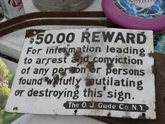
MM 338- an old Blue sign much larger than the functioning ones. This one was nailed to a wood post only about three feet off the ground- also covered in the holes of bullets shot from the river.
DOES ANYONE KNOW ABOUT THE OLD BLUE MM SIGNS???
I took a photo and ripped the vines off of the faded 338. The sign popped off the post; a moment of guilt! I'd never seen one like this before, and now it was dead.
The post was rotten and the nails had no chance- I leaned the sign against it and returned to the boat- I felt guilty for killing the only sign like it- another mark of history here on the river. I was tempted to take it- It was already dead, right?
I started to launch the boat- the cold water inside had turned warm in the sun.
With the sign strapped to the back of my 9' boat I was back on the water- It is only three feet wide, but my kayak was not even two.
I forgot about the wind and traveled to the middle of the channel; the sign hanging from both sides (and the back) of the boat acted like wings!
It was not going to leave the boat- tied with the strong nylon that secures the boat to the top of any vehicle- but it certainly made the boat a bit more vulnerable to a strong side-gust!
I pointed the nose into the wind and the wind gave another push- I worked to get back to the bank that was protected by trees and the straps howled and buzzed like they would on the hwy. Off balance- the nose scooted just an inch to the right and the wind had me!
It whipped around and I was off to the wrong shore. I paddled
backwards- lucky to be upright!?
The wind died within only a few seconds to a more manageable speed and long enough for me to slide back into my safe-zone!
Only two miles to the
sandbar! The sun baked my shirt- it felt so nice to have the sun back from winter! I took my shirt off and basked
for the last stretch of the day's float. The stolen sign made a
convenient addition to the back of the skinny kayak- I laid back and felt the river and the sun and breeze.
It is really spring!

More of the sandbar was exposed than Ive ever seen! Much of the new land was gooey mud, but dry gravel was everywhere!
I pulled my things onto the middle of the island- far upstream of the bridge. Today, about two-thirds of the island was upstream of the Sibley bridge- it's length exceeded a half-mile! I crawled towards the bridge-
immediately I found pottery and bones. Most of the pottery was of the Fort's era- some cool Indian stuff and lots of crock-
lookin' pitchers and jars.
Lots of glass here- jars, bottles and everything else! One small bottle- about the size of a cassette tape and only twice as thick- Reads:
"HINDS HONEY AND ALMOND CREAM- A.S. HINDS CO. BLOOMFIELD N.J.U.S.A."
Turns out that the company who made the cosmetic left the
NewJersey factory in '48!
By far the best finds of the day were a very
mineralized Bison's jaw and teeth and a piece of green slag glass that had been polished a
lmost completely round by the river- I found a matching piece of glass that was not as polished.
I paddled upstream- over several bouts of rapids and fast water entering and exiting a pair of large box dikes- The sun was low and any shade felt especially cool on my toasty shoulders!
The sign limited the length of a paddles
stroke- ended it about six inches short- and hopping the shallow rapids of the river pouring into slow areas was much more
difficult than it should have been.
The wind was to my back when I fought the current to cross the river.
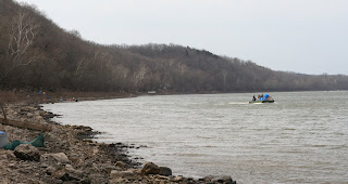
Sibley's only boat ramp was directly across the strong river from the place where I popped out of the box dike- my mom stood behind her huge dog to watch me loose.
Still, I hit the ramp's shore only a few yards downstream and the last few minutes were easy!
The boat was especially heavy when I lifted it- Ma' helped me carry it to the top of the ramp and empty all of my treasures... Everyday could be this nice!
The road to the Sibley ramp passes over a very cool one-lane bridge!

 Is a March 30th-snow so unusual for the city I live in? Its odd how oblivious I am to the norms of a place as familiar as Swope or even my city.


 The birds were
 The trail was short and easy- the old mines and relics of sorts lined every inch. An old ore cart lies off one side of the trail.. stiffened by rust and protected by the high wall that it served to create. Ore tracks- complete with mini-railroad-spikes- were abundant. These too were dying.


 An eve of stars and one of clouds- The deep Ozarks are beautiful and refreshing in nearly any condition. The flowers- delicate spring-ones- are the most unusual, attractive feature of this North Arkansas spring. It looks and feels like there should be mushrooms out, but there is not much around.
 The dirt is moist and fertile- growing things are everywhere- still there is something more impressive...the same thing that captured my attention on the long drive south and that which has altered the entire span of the Ozarks so dramatically.....Sawdust, fallen trees- mangled, shattered branches- The destruction is as bad on the ground as it is in the standing forest. The winter's disabling ice storm is still
  On day II mom explored more of the


 There is a dump on the
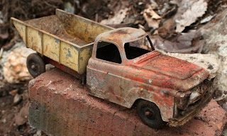


 ......1Car Fender6 large pieces of Styrofoam20 ft. of Corrugated Pipe42 ft. of misc. Pipe1 Cooler7 5-gallon plastic Buckets
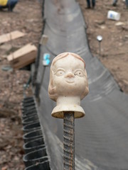
 ...And this thing; a giant trash shoot cut from materials that floated ashore on the Missouri at Alligator cove, near KC. River


 A
A 
 The sand and gravel seems endless here. Today the sandbars appear more than three times as wide as they are at a more 'normal' river level- though they
  There is little to be found on the first sandbars- I slipped around two very dry wing-dikes to get to the best stretch of adventure. Immediately I found bones and bottles that had not been exposed on my last visit. Much of the bar was unrecognizable- A few objects, maybe, about seven feet inland. That yellow toy
