Showing posts with label Missouri River. Show all posts

Monday, October 12, 2009

Kansas City River

AUG. 12
A float by Bill; some photos I found from the beginning of August. Bill and Ruth invited me to float on the Missouri River for an afternoon. The weather couldn't have been better! We launched a mammoth 3-person Canoe from Kaw Point - The confluence was our first obstacle, but the heavy boat kept a smooth course through any turbulence beneath us. We traveled under the first few bridges and a trail blew its whistle on the bridge upstream of city market. There was a good story to the name of our vessel, but I forget both.
Bill tried introducing us to a betting game. "Train-Car Poker"- He explained that the game was played by betting on the last car, the second to last car or the third. When the tail-end finally shows up and reveals the identification numbers of the last three boxes, the numbers- I think that there were like five digits to a car- were played as a poker hand. Bill's last car, "Number-one" started with a lucky pair of 7's and a pair of 2's. Ruth chose to bet on Number 3, which beat my silly second car with a pair of 5's.
The City Market overlook was identified and we tied-off to one of the old wooden pier-supports just down from the overlooks hefty cement ones. We scrambled up the rip-rap, alongside the pillars, and overcame the weeds and briers to hop a fence and walk the stairs the rest of the way. Ruth and Bill posed for a photo, and I took a few of the downstream bridges. The river was beautiful all dressed-up in it's summer greens and with those fluffy afternoon clouds. We glanced across the bridge that connects the overlook-island with the rest of the world. Ruth spotted a small group of friends and everyone met to catchup. Bill tried explaining to me what little he knew of the folks and we showed our finest smiles for Ruth's extended family.

The sun sank into the thicker clouds as we approached another large bridge on the water. I lost another round of Train-Poker and Bill told us that all of the commotion that appeared to be on the next bridge was the beginning of construction for the new I-35. The next bridge was the last one before our take-out. We neared the construction, where they had a HUGE crane floating on a barge, and more equipment and materials on others. The sun vanished below treeline. Bill spotted a beach that he remembered camping on; Ruth told Bill that the large sandbar was not the one that he remembered. The disagreement was definitely a good excuse to stop and investigate. The dark sandbar held only a set of tire tracks and a block of dock-foam, and after Bill was convinced that the sandbar was not the one he remembered, and that night really was coming fast, we launched the dock foam and gathered our things. The canoe could not catch up with the minutes-head-start that the block of styrofoam had with the current and with only a quarter-mile of river to go before our takeout on the opposite bank, the three of us put some effort into paddling for the first time on our four-mile-run. Bill steered us across the river so that we paralleled the nightly shore with only an easy bit left to float. A spark of lightening lit parts of the Northwestern sky and it appeared that we would be on dry land just in time as the unexpected storm approached.

Of course you could hear the surprise and tension in his voice when a gusty front-wind broadsided our placid canoe. The winds whipped across the river and down it's channel, and with nothing to obstruct it, it hit hard. For a moment the wind seemed to push us ashore- it was all-of-the-sudden so loud! My instincts were to get to shore and only a few hundred feet of water flowed between us and the boat ramp. the boat-ramp projected from shore to form a slower current upstream of the thing, and a much faster one around it's point; I wanted to get the boat to shore quickly and I didn't like the looks of the speedy current forming on the ramp itself. I started to paddle towards shore, though I made little progress with two other determined paddles on board. Bill was headed for the ramp! The wind changed directions and thunder and pouring rain started against us at the same moment. We were in the storm way too quick!

Bill shouted a few things that I did not hear and we beached the boat just upstream of the ramp. The scene was chaotic, but we managed to carry the boat and our things up to the lot- tied it to the cables between cement blockades and hid the canoe on the river-side of a block that outlined the parking area. The rain continued and it wetted each of us more than we would have hoped. We piled paddles and packs into Ruth's little car and she got us back to Kaw where the bout of exciting weather had already come and gone. Ruth yelled her goodbyes from the driver seat and left Bill and I to retrieve the boat with Bill's big truck. I asked bill to allow me a few seconds with my tiny camera and the dramatic night scene of Kansas City's Downtown engulfed in the storm.The damn thing didn't do much good for the photo's potential; I gave it up after three very different exposures. It was a beautiful thing, though!

Through Downtown and the city market area that we visited via the river. Bill made one last swing of his arm to point down the way that would take me to the same Overlook-

We loaded the boat in the rain again; the canoe was flipped and moved away from the cement so that Bill suspected aloud that someone had tried to steal it. My immediate thoughts blamed the boat's position on another stray gust of wind that may have come with the storm in our absence. I kept it to myself.

We lifted the canoe in an a light rain, and fastened it to the bed as heavy rain turned heavier. One heavy mess of rain forced traffic to slow down on the ride home.

Tuesday, July 7, 2009

Sioux City


Visit Vicki's awesome RiverNotes post; I think that I will only be sharing some pics for this one!

Wednesday, May 13, 2009

Yankton

I started off at the Cabin, near Squaw Creek on Big Lake. We had only sun until late, but the area was constantly under a new Severe storm or tornado watch. Some very cool clouds popped up at dusk- they sat underneath a bright moon. I walked down the the cemetery to take a photo with the old 35mm. The trees are beginning to look very green! Thunder and far-off lightning arrived after sunset, but we got no precipitation. I woke up in a thick, wet fog-mist and drive north under menacing clouds and through several short showers- I met Vicki in Yankton on Friday afternoon- just as the Educational event was coming to a close. I hung with Vicki, John and Alex and helped where I could. Yankton was rainy and rather soggy until hours after I arrived. Blue skies shown bright for an hour or so and I got my things into one of the steel boats; the rest of the crew would arrive later in the day to meet us on our island-camp! I set upstream on my short kayak- The camp was only a half-mile or so from Yankton's ramp.

I paddled and worked to compete with the oncoming flow, and made it to the double-decker bridge before a great, ominous shelf cloud boiled it's way over the city. i saw the thing coming and paced myself carefully to make sure that I would be in a shallow spot under the bridge in case the storm became too wicked. It hit with force- a cold northerly wind blasted at, according to one weather report, 45-60 mph, with damaging gusts exceeding 80mph...

Being on the water quickly became a dangerous idea and I worked against a miserable wind to beach the boat. the dark shelf-cloud passed- I took some dramatic photographs of the storm over the bridge on the city from the water, but the driven rain turned into hail and I sought refuge under my life jacket- removing it from my body meant I would become very cold. The rain slowed and I regrouped and took hold of the kayak's front handle- I wanted to walk to regain my body heat.- I know that I should have been better prepared, but I cant imagine that anyone was prepared for the storm that battered the upstream portion of the city! I wondered how John was doing with the boats.


The wind continued, and formed large white-capped waves that sped downstream with the storm. The persistent stinging rain became miserable pretty quick, but I drug my boat to at least some relief; the shore was all flat sand and mud until I needed to cross a slim, deeper braid in the river. I started to wade across. Already wet, I was not afraid to sink stomach-high in the milky water, but I carried my camera with me and returned to shore to hop in the oat and battle the wind across. About halfway across I caught a good gust and sailed onto a sandbar- I had to get out to launch the kayak again. The rain was gone after another tenth of a mile or so- just as my legs began to tire from towing the kayak. The clouds were obviously breaking up and I got out onto the main channel as winds slowed. I made it to the camp where only one tent stood sideways with a shattered pole. With the kayak secured high on the sand I entered camp- I tried messing with the crippled tent for a second; I stood it up, but did not want to make matters worse and left it. I began collecting firewood- the wind was still intense, but it was surprisingly dry- it felt warm. I stumbled into a pair of juicy Yellow Morels and immediately became distracted...
I jogged back to the kayak and grabbed the camera; it took me the length of the short trek back to the mushrooms to realize that the lens had been temporarily rendered useless by bubbling condensation. I picked the mushrooms and walked another few steps to find one more. I stashed them in the mess kit that I had brought over. Nobody came, and I wandered down the beach -towards the bridges with the wind at my back- Maybe there was a cool stone or fossil to be found? Many fossilized bone fragments sat amongst the largest gravel-

I got to the tip of my island-far downstream of camp, where that deep braid returns to the river. The sharp, shallow point was repeatedly overcome by the wind's largest waves. The slightly-green water is still cold from northern snow melt and cool nights. A large, ancient vertebra sat in the shallows of the point- I stubbed my toe on it while only ankle-deep!

I ignored time and made my way back towards the camp and my boat. The wind whipped at my face kept my hair horizontal. It felt good, but just as I began to feel that I must be close, I caught a glance of my bright orange kayak- rushing over a log and propelled by an unusually gust of dry wind. Immediately I thought of the camera that I had let to dry on the anchored boat, and the thing rolled into a tree not far from me- nearly 30meters from where I had left it! The wind hit me with a blast of stinging, blinding sand- My camera was dead- the lens was lodged under a large drift-wood trunk and the unprotected body was partially cracked and filled with camera-killing sand. I was frustrated and saddened by the loss, but the sun came out again and I couldn't feel bad in such a beautiful place. I still had the 35mm........

Tuesday, March 17, 2009

Sibley's River

Mountainmen and Fur traders, as well as many Osage Indians traveled for days to reach Fort Osage- often floating of hiking the river.
It was in 1804 that the area's first non-indian settler, Pierre Chouteau of the Chouteau Fur Trading family helped take Osage chiefs to meet President Jefferson. The President promised to build the Natives a trading post which, thanks to Chouteau, was erected in '08 and named Fort Clark, after William Clark, who noted the area in 1804:
"high commanding position, more than 70 feet above high-water mark, and overlooking the river, which is here but of little depth"

Clark was also the head of Indian Affairs when the Fort was named. The Fort was one of the first U.S. military installations in the Louisiana Purchase and served as a stopover and trading post for river-travelers and the Osage indians. FOr the military, the post meant regulating trade and was a method of establishing peace (and control) with the Osage people.


The fort was given the name Fort Osage and a gentlemen named George Sibley succeeded Chouteau as the Osage Indian agent. George mingled with traders and visitors alike and made for a welcoming host of Fort Osage with his 16 year-old wife... Frequents knew the Fort by the name Fort Sibley.
the year 1821 marked the arrival of J McCoy, founder of Westport on the Santa Fe, and The admission of the State of Missouri to the Union. A year later, the Fort Osage operation was formally ended by the military, and used as a storage area for posts in Leavenworth and along the Osage River near Nevada, MO (Fort Scott). Cut Wood from the post was salvaged by the early local residents until only the Foundation stood at the end of the decade. George Continued supporting the small community that he helped raise with favors and a small trading post.


Independence and McCoy's "Westport" went on to compete with each other (and later St. Joe and LEavenworth) for the area's trade dominance. McCoy's trading post dominated because of it's strategic location only four-miles south of the missouri at it's confluence with the Kaw- then known as 'the Great Bend." The GReat Bend marked the eastern-most point of the river's southern stretch. This allowed merchandise to be floated almost 20-miles upstream (west) of the existing western stop on the Santa-Fe Trail- Independence.
Travelers began skipping the established trading posts to take advantage of Westport's 20-mile advantage and McCoy's business founded modern-day Kansas City.

Sibley passed and the community which he created claimed township under the name Sibley, Missouri. It remained a relatively quiet place as the Civil war ripped border towns like Westport, Leavenworth and Lawrence; Jackson County remained almost entirely pro-south until the Union ended Confederate military operations of the area in '64 (The Battle of Westport)...

1969 meant the opening of the Missouri's first Bridge, located in McCoy's City of Kansas (Lawrence also wanted the Bridge). The Hannibal allowed for railroad travel from the north- thus triggering a great bloom of population and industry (primarily cattle) for the City.

Almost twenty booming years later, and a year after the Hannibal was partly destroyed by a tornado, Sibley got its own fine railroad bridge- The three-span bridge has existed there- just miles upstream of the busy Fishing river since.
KC's Hannibal Bridge was replaced by a two-level bridge after the turn of the century- The Second Hannibal Bridge opened in 1917 and was replaced again by the Broadway Bridge. Bridge #2 had a top deck just for vehicles!

The foundations of Fort Sibley were re-discovered only sixty years ago and it has since been rebuilt to model the Fort as it appeared in 1812. Fort Osage is a National Historic Landmark which hosts many demonstrations of the 18-teen's lifestyles for public audiences and often is the only thing for which the modern 1-square mile village of Sibley is known..
Cooley Lake conservation Area is mile-marker 339.5 on the Missouri- only about 4 miles upstream of Sibley and the Sibley railroad bridge... .
The bridge itself is certainly worth of the paddle, but today I was after the relics of Ft Osage on the HUGE ISLAND SANDBAR that the bridge supports. Only about a quarter-mile downstream of the Fort are the first signs of the island when the river is as low as it is today(7 ft.) I have been lucky enough to find things like trade beads and wet stones on the sandbar, as well as the fossils and bones that are to be found on the entire length of the river.
There is an SUV in the water- only a few yards from the Cooley boat ramp. The thing has been there at least a year and is still sinking; today only about 8 inches of it stood above the waterline. The eight inches have kept the tan paint well- at least in those places that are not torn with bullet and shot holes. The marks have occurred only since the SUV was abandon; the CA is a hot spot for illegal target practice. The river-buoy which float about a hundred yards from the shore are also graffitied with holes.
The Suv is only half-way between the ramp and another Cooley-landmark: The boat. This small runabout has been upside-down and underwater for much longer-

The bend here at Cooley Lake is in a constant state of change- it's small sandbars and levees will be in a different- grown, shrunk and in a different place: Always, though, there will be one or two spots here, in between the new debris, that one could find a bison tooth.

Early-season 70's make the float warm and peaceful. The wind was picking up, but I stuck to the left bank to escape any gusts. I floated past another busted boat and a few appliances- Spotted a good section of the pipe that was used to create the trash-slide-thing for Jeff City's clean up.

A Missouri River mile-marker; It was low and overgrown- Blue?- hardly visible from down on the water. I spotted it as I cruised past, but had to inspect- made a hard sprint back upstream and climbed the rip-rap up to where I knew it was.
MM 338- an old Blue sign much larger than the functioning ones. This one was nailed to a wood post only about three feet off the ground- also covered in the holes of bullets shot from the river.
DOES ANYONE KNOW ABOUT THE OLD BLUE MM SIGNS???

I took a photo and ripped the vines off of the faded 338. The sign popped off the post; a moment of guilt! I'd never seen one like this before, and now it was dead.
The post was rotten and the nails had no chance- I leaned the sign against it and returned to the boat- I felt guilty for killing the only sign like it- another mark of history here on the river. I was tempted to take it- It was already dead, right?
I started to launch the boat- the cold water inside had turned warm in the sun.

With the sign strapped to the back of my 9' boat I was back on the water- It is only three feet wide, but my kayak was not even two.
I forgot about the wind and traveled to the middle of the channel; the sign hanging from both sides (and the back) of the boat acted like wings!
It was not going to leave the boat- tied with the strong nylon that secures the boat to the top of any vehicle- but it certainly made the boat a bit more vulnerable to a strong side-gust!
I pointed the nose into the wind and the wind gave another push- I worked to get back to the bank that was protected by trees and the straps howled and buzzed like they would on the hwy. Off balance- the nose scooted just an inch to the right and the wind had me!
It whipped around and I was off to the wrong shore. I paddled backwards- lucky to be upright!?
The wind died within only a few seconds to a more manageable speed and long enough for me to slide back into my safe-zone!
Only two miles to the sandbar! The sun baked my shirt- it felt so nice to have the sun back from winter! I took my shirt off and basked for the last stretch of the day's float. The stolen sign made a convenient addition to the back of the skinny kayak- I laid back and felt the river and the sun and breeze.
It is really spring!
More of the sandbar was exposed than Ive ever seen! Much of the new land was gooey mud, but dry gravel was everywhere!
I pulled my things onto the middle of the island- far upstream of the bridge. Today, about two-thirds of the island was upstream of the Sibley bridge- it's length exceeded a half-mile! I crawled towards the bridge- immediately I found pottery and bones. Most of the pottery was of the Fort's era- some cool Indian stuff and lots of crock-lookin' pitchers and jars.
Lots of glass here- jars, bottles and everything else! One small bottle- about the size of a cassette tape and only twice as thick- Reads:
"HINDS HONEY AND ALMOND CREAM- A.S. HINDS CO. BLOOMFIELD N.J.U.S.A."
Turns out that the company who made the cosmetic left the NewJersey factory in '48!
By far the best finds of the day were a very mineralized Bison's jaw and teeth and a piece of green slag glass that had been polished almost completely round by the river- I found a matching piece of glass that was not as polished.

I paddled upstream- over several bouts of rapids and fast water entering and exiting a pair of large box dikes- The sun was low and any shade felt especially cool on my toasty shoulders!
The sign limited the length of a paddles stroke- ended it about six inches short- and hopping the shallow rapids of the river pouring into slow areas was much more difficult than it should have been.
The wind was to my back when I fought the current to cross the river. Sibley's only boat ramp was directly across the strong river from the place where I popped out of the box dike- my mom stood behind her huge dog to watch me loose.
Still, I hit the ramp's shore only a few yards downstream and the last few minutes were easy!
The boat was especially heavy when I lifted it- Ma' helped me carry it to the top of the ramp and empty all of my treasures... Everyday could be this nice!

The road to the Sibley ramp passes over a very cool one-lane bridge!

Thursday, March 12, 2009

Osage at the Capital

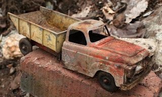
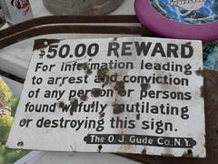
There is a dump on the Osage river, only miles from it's confluence with the Missouri in Jeff City- it is one that has certainly not escaped the attention of the River Relief. With well over a half-century's crap flowing down the poor hill over the river, it seemed that treasure-hunting was what kept the majority of our 160-someodd volunteers bagging what they could. The most coveted finds of the day included An old steel toy pick-up, a bucket of antique glass and a mangled, shot, mutilated sign reading:

$50.00 Reward for information leading to the arrest and conviction of any person found willingly mutilating this sign


Volunteers pulled over 13 tons of 'trash' from three separate sites along this section of the osage on Saturday.

From the MRR blog

Filling two 30-yard dumpsters of scrap metal and one 30-yard dumpster of landfill, we found (at least):
106 large bags of Landfill Trash

76 large bags of Scrap Metal2

4 32-gallon trash cans of Broken Glass

210 Car & Truck Tires2 large Tractor Tires

2 Tractor Inner Tubes

3 Refrigerators

9 Washing Machines

1 Dishwasher

2 Driers

3 Hot Water Heaters

1 Tricycle

1 mangled Bicycle

......1Car Fender6 large pieces of Styrofoam20 ft. of Corrugated Pipe42 ft. of misc. Pipe1 Cooler7 5-gallon plastic Buckets6 metal Buckets1 cast iron Pot3 Stoves1 Stove Front & Drawer2 Stove Tops & Pieces1 massive Brake Drum1 metal Love Seat Swing11 Box Springs1 Head Board4 Cow PanelsSeveral rolls of Barbed Wire25 ft. of Cable Wire8 Rolls of Fencing7 Chairs1 Lamp1 Toilet1 MO 98 Road Sign2” Copper fitting (Steam)1 Hog Waterer3 metal Hub Cap’s1 Fender from Antique Truck½ of a Car front end Grill & Headlight1 Alternator1 Crank Shaft1 Car Seat Springs2 Tail Pipes1 Drive Shaft2 pieces of Carpet8 pieces of roofing Sheet Metal½ of a Pasture Gate1 double Kitchen Sink1 Counter Top1 boat full of assorted Wire & Fencing1 ancient Boat Motor1 coil of Heavy Cable1 Sewing Machine1 Culvert1 Tractor Gear Box1 Air Filter for tractor1 mini Ironing Board1 Hide-a-Bed Frame8 welded Wire Hog Panels1 cast iron Furnace Grate1 Brush Hog Deck30 corrugated Metal Panels1 VCR1 push Lawnmower1 antique French Fry Cutter1 Snoopy Soap Dish2 sections of a toy Train Track1 headless Raccoon Statue2 Teapots2 Wash Tubs1 toy metal Dump Truck1 See Saw1 Baseball Glove

1 shot-up Sign that reads: “$50 Reward for information leading to arrest and conviction of any person or persons found willfully mutilating or destroying this sign. The O.J. Gude Co. NY”

1 toy Cash Register

1 soggy book titled “Shaping History”The letter “C”

1 decorative Perfume Bottle ...And this thing; a giant trash shoot cut from materials that floated ashore on the Missouri at Alligator cove, near KC. River Relifers cut the mega-tubes in half and nailed them to the side of the hill so that trash from the largest, steepest dump could be expressed to the boats without all of the busted ankles. We sent dozens of huge trash barrels full of scrap and trash down every hour- the barrels were emptied and recycled back to the top while their contents were sorted, bagged and sent back to the ramp via boats. Genius!

It worked very well; no accidents and several tonnes of trash GONE! The thing was the center of attention throughout the day and even served as a nasty, surprising fast ski-run when paired with the lid of a trash barrel. Congrats RR!


Friday, March 6, 2009

North!

A parkville adventure!

Wow! How sore are your calf muscles after so many hours on a good sandbar?
I spent more than six hours on my feet Thursday...
The river here was the lowest I have ever seen it; under five feet! The low gauge measurement was enough to get me off of the computer and onto the water- I was hiking up a sandbar by noon.

An unusual hike to the first gravel bar; exceptionally warm and beautiful. This winter day would exceed 80-degrees in sunny Kansas City. A sand dredge was piling material on a barge right in front of the baseball diamond and a crowd gathered to watch from the short fence
Someone has marked up the riverside and trail with all sorts of purple "Keep OUT" paint- so much as to have traced the actual property line on the ground with the paint. Leaf-litter, sticks, rocks- all purple.

That's okay- if I am really trespassing here, I am one of a mob of Parkville folks who have no alternative for a river walk.
The sand and gravel seems endless here. Today the sandbars appear more than three times as wide as they are at a more 'normal' river level- though they don't feel much longer.

New logs are exposed- the dark, heavy things are definitely the first thing I notice- After that, though, my eyes cannot brake from the immediate gravel at my feet. There is so much to be found here .

Fossils, crystals, bones, pottery, and more familiar things like broken ceramics and glass bottles from only a century ago. Most of the newer stuff- the trash, plastics and even tires- all floats until it is caught by a log-jam in a flooded river; these piles of light-weight debris accumulate on the higher parks of the bank- often on the first terrace. the ones here definitely need some help- Amongst the stacks and tangles of natural things are many thousands of plastic bottles, a few 55-gal steel and plastic drums, some sports balls and articles of clothing and even what appears to be a stove.

At the start of the sandbars you can still see the barge-dredge thing; it peeked around the bend, under the 'castle' only half a mile away.

There is little to be found on the first sandbars- I slipped around two very dry wing-dikes to get to the best stretch of adventure. Immediately I found bones and bottles that had not been exposed on my last visit. Much of the bar was unrecognizable- A few objects, maybe, about seven feet inland. That yellow toy tonka-thing (it's sat here for years!) was elevated to the height of my chest when I stood at the water's edge- still tangled in a few crooked branches.
Only one set of footprints had reached as low as I had- I'm sure that their owner collected may wonderful things!

A hint of blue- i knew the colour when I saw it glance from beneath a tiny breaking wave. a single sandy scoop revealed a beautiful fossilized bison tooth! It is by far the most colourful Ive found!

It was more that three hours before I reached the end of the longest of parkville's sandbars-
60lbs of bones and a boulder of coal later...

Saturday, February 14, 2009

The City-Kind of River

As the Missouri River flows into the Kansas City Area, it enters one of the most developed, engineered and polluted stretches of it's 735-mile channelized route from Sioux city to the Mississippi. Here, the river that created the city- with the construction of the first crossing in 1869, the Hannibal bridge- is degraded, abused and partly destroyed by pollutants. Chemicals as common as fertilizers and herbicides, litter and even the noxious amounts of silt and sediment from it's own floodplain are saturating every part of our local watersheds. Incredibly, the river has been able to endure over 170 years of such disgrace- because we live with the water (and rely on it!) everything we do impacts the river in an unnatural manner- from the electricity we use to the channelization that was ordered by the Pick-Sloan Plan in 1944.

More recently (even in my lifetime!), as Kansas city has become the largest city in the Missouri's basin, increasing sand-dredging operations have degraded the riverbed within city limits as much 4.5ft, according to one 15-year study completed in 2005. The sand is used in the production of cement and our intense rate of growth feeds the industry to the point that we are seriously injuring the river's bed...At the turn of the millennium, about 7.4 million tons of sand and gravel were removed from the navigation channel annually, primarily south of Rulo, Nebraska. (rulo is only like 80miles as the crow flies)
Even as channel dredging poses an increasing threat to the river, it is only a small portion of boat and barge traffic here, and an almost insignificant one compared to the sediment, chemicals and litter dumped into it by other industries and sources in our city. Sand dredging operation: This one, near kaw point, was anchored but not operating.

Please do not think that I find the river disgusting- I love the Missouri!
I cannot say that I dont find it's neglect pretty sickening, but even this is something to be learned and appreciated about the river.

I was invited to cruise the section of river between riverfront park (I35) and Parkville with fellow River relief volunteer and trainee John Jansen while he developed his driving skills on calm water. Dave brought the boat- he played supervisor (and tour guide!) I sat on the trash near the bow- the elevated front of the boat protected me from an icy wind. John and Dave, however, sat in the worst of it and even John's arctic outfit left him frozen! We zipped upstream and Dave gave a history or identification to almost every landmark, bend or barge we spotted!

John and I arrived a bit early- spent our time collecting simple litter at Riverfront's boat ramp. There is no obvious dump here, but the amount of trash left by park visitors wasn't uncommon. Again, fast-food Styrofoam was the most abundant litter, but glass bottles, cans and fishing gear were also bad.

I found several medical-syringe-type bottles and fortunately no needles. An odd contraption anchored to shore with some rusted wire- a trap I guess- The thing was made of a tin can with many holes, about eight feet of wire and a piece of iron rebar. We collected two hefty bags worth of litter, and still the place needed help!
A cold, cloudy February day, but still it was so nice to be out on the water! Thanks John and Dave!
....AND LOTS OF BRIDGES! My favorite of this stretch has got to be the 7th street pair- bottom photo.

Wednesday, February 11, 2009

Old Plank

It was already late in the day when I reached columbia and the river. The wind was wicked- 'blew strait down the channel from the south, creating an incredible series of white-caps on the Missouri River. The air was warm- like the rest of the weekend, this beautiful Friday's forecast was sunny and upper 60's! ... perfect for the last-minute Old Plank road Clean Up. Still the wind was tough!
The sandbar was very exposed- more so than Ive ever seen it before and I NEEDED to get out and explore it. My small kayak would surely be beaten by the wind and waves; The water was WAY to cold to swim.

I spent some time taking the ol'e 35mm for a walk around the area, but the sandbar was screaming for me every time I caught a glance of it.

I slipped the lil' 9-foot boat over the mud and hopped in off the backside of a wing dike slightly upstream of the sandbar. ' made a few strong strokes with the paddle and shot off the edge of the dike and into the current- and the wind. It immediately swung the light nose of the kayak upstream, so to minimize my resistance to that nasty wind.
I paddled continuously and as best as I could. The icy waves came over the back of the boat and the wind made it near impossible for me to keep on a strait track- I decided I was not going to be able to reach the sandbar and turned back near half-way; the point of no return!

Got to shore- most of me pretty wet and numb despite the warm air and hot sun. I had not reached the sandbar and it's temptation seemed many times worse than before I'd failed. The thing continued to drive me nuts through the evening.
I changed and returned to the Medfly. Folks I did not know and those River Reliefers I was familiar with continued to accumulate through dusk- A GORGEOUS SUNSET!
Steve, Mel and Anthony were kind enough to put me up in the trailer (really had no idea where I was going to be spending the night!)

There were no more than a few dozen volunteers on Saturday morning; I had a fine meal from one of the Landing's fine cooks and Steve gave a rough plan for the day- Mr. Brady volunteered (or maybe he was volunteered) to take a group of folks up to Hwy K and I joined.


I stuck close to Anthony- We hit Hwy K and had walked our first mile in no time! Anthony caried bags to collect recyclables- Much of the litter we removed Saturday was recycled- Most of the largest trash had already been removed, but the little stuff was everywhere!

Lighters, Cigarettes, fast food containers, beer cans, bum lottery tickets and empty Skoal cans filled many bags pretty quickly, but the torn wrappers of Swisher Cigars were the most common things found on the side of the road...

And whats a clean up without the weird things?
A nearly full bottle of Kiwi Liquor, a dump of glass Clorox bottles, a dead barbie doll and a decapitated dog. Our small group worked about 2.5miles of road, and another group did the other 2.5- All in all, though, we removed only like 35bags of trash!?

The Old Plank Road clean up has maintained this stretch of the road annually; Saturday being it's fourth clean-up.... The trash is less and less every year- last year, Steve said, they picked up over eighty bags of trash. CONGRATULATIONS VOLUNTEERS!

This year was my first time picking trash off of the road as part of this group- Maybe next year the amount of trash will not be worthy of a clean-up event!?
We found other things on the side of the road, too; Folks claimed feathers and skulls for themselves and I found this odd bunch of juicy red berries hanging only a few inches from the ground on a rotting stem. They kinda reminded me of Jack-in-the-Pulpit, but would such things still exist so many months after being produced?

The bags were piled into a long trailer and all troops were returned to the Landing only a few hours after we'd started. A quick group photo and a meal donated by Cooper's Landing; many volunteers disappeared pretty quickly, a few stayed behind to yak with friends..

The air was growing warmer and the thick grey clouds which had smothered the morning were lifting and moving north. It wasnt all good; The wind that had been barely noticeable when we woke up was ripping down the channel almost as viciously as it was yesterday- I still needed to get to the sandbar...

Arrowheads that were taken from the bar had been flashed around all day- big, beautiful tan ones and some that had a hint of pink and purple.- Even a long white spear point- perfect and about 5 inches! I'm bound to find one someday!

Intimidated by the wind and water, I resorted to a stroll down the Katy trail- Its only a minute or two until you reach the BOAT HENGE!

I made my way down to the water and I felt so close to the sandbar- it would make a fine swim if you were not risking HYPOTHERMIA! The wind was a bit more calm down on the water-I decided to try again.

The kayak slid down the steep bank underneath the trailer easily- I tossed a life-jacket on and made a mad sprint upstream in the fastest currents. The wind was certainly not as bad as it was up topside, with a few gusty exceptions.

My paddles tore at the surface of the river in an attempt to squeeze upstream of the tip of a wingdike- The water at the end of the structure moved so quickly as to push me downstream when I was caught putting less than one-hundred percent of my energy and focus into paddling. 'Overcame two of them- smooth, slow water in between- before I was able to pull my boat to the side of Cooper's boat ramp. I made a quick peek up at the trucks and let John know where I was headed- he could only wish me good luck, and I know that he wanted to get onto the islands as much as I did.


Though the wind was strong, it came at an angle that allowed it to be partially blocked by the trees and topography on the west bank and made for an easier headwind rather than one that would push me sideways. The water was cold- a few drops that ran down from the blade felt like ice on the parts of my skin that'd been warmed by the direct sunlight

The first step from my craft landed me knee-deep in a soupy pool of sand- the same spot that appeared firm when I ran the kayak onto it. I feared the loss of my loose shoe, but it stuck with me for the few steps it took to find land. that same icy sensation met the wet part of my legs, though it took an extra second to realize. I pulled the boat until I was sure it was safe from floating away- it would kinda suck to be stranded on the other side of such a cold river!

... It would be several hours before anyone would hear from me again... I finally got my sandbar adventure, and though I never found that arrowhead, I did get a lot of cool stuff! Some shards of ancient pottery and some knappings, a cool scraper. The small dunes that held the largest sediments appeared much darker than the sand-

The materials were sorted by shape, size and density and were painted onto the sandbar like clouds in the sky- I imagine you could learn alot about hydraulics and the river here- universal knowledge that could be used to understand any flowing body of water, and even things like weather and the geography of the mountains and the badlands. It can all be had by studying the tumbled, experienced debris- they are laid in the river's language...

I waded into the cold water- maybe I would have a better chance for an arrowhead if I searched the parts of the sandbars that were submerged and likely undiscovered. I was surprised that my legs and feet withstood the ice for as they as they did- little pain until the end, though not much feeling, either! .. Nor were there arrowheads.. at least none that I found. Still, more cool petrified wood.

The sun went in and out of the clouds and the wind began to die down. . . The sandbar was becoming clam and peaceful; it would be the first time since I saw the sandbar that it could been perceived as such. My thin leather shoes were tight on my feet- Maybe it was the cold, or simply the globs of wet sand in them. It didn't matter, and certainly was not worth the taking the time from my hunt time to investigate!

I walked downstream- maybe a quarter-mile to a small channel that made this bar an island. It looked shallow, and only about ten or twelve feet across. I stepped into the water and it felt much colder than the wading I did just a few minutes earlier- I began to walk across, though my feet led me at more of a diagonal as I discovered more wet gravel piles. The diagonal didn't last long though; The water was turning painful! On the other side there were many more sandbars- about two hours worth with some fast-paced skimming. I gathered two more handfuls and a pocket of the most valuable materials, but no arrowhead. The sun poked out again and light the sandbar- I snapped a photo and then one of the melting ice-lilies that had become trapped in a small cove behind the nicest gravel bar. They were beautiful- had a texture on 'em that was something you could only find on ice- a smooth, polished checkerboard-like pattern. THe black, glassy water and ice made for a kind-of surreal look,

I turned back- It was nearly a half-mile to the kayak! The boat could hardly be seen. It took me a second, but I made it as far as the small channel. TOO MUCH treasure; I filled my pockets and made a pouch out of the front side of my t-shirt. One last wade- I only made it knee- deep before I felt the burny-stingy frozen pain this time- It seemed, also, to go deeper into my skin, as well. I gave it a quick burst of energy and made it out. Alive !

The pain got worse, but then quickly receded; For the last of my short trek my feet would grow increasingly tender and I soon became aware of just how much sand filled my shoes.

Another boat- the big, aluminium canoe that usually rests on the boat ramp was beached near mine. It's two bare-footed paddlers were exploring the sunken part of the sandbar as I had. I made a pit-stop at the kayak to drop my camera and offload all of the wonderful things I'd collected before approaching the men. They, too, wore swollen, jagged pockets and handfuls of rocks. One paddler was excited to share all of his cool agates and the other gave a very enthusiastic spiel about all of the cool flint-workings that they have recovered in the past, and those they'd found today. He showed me some very cool things- scrapers and knappings like I found. They visited my kayak for a glance at my treasures and were most excited about some of the unusually large amber-coloured agates I brought from the other side of the small stream. We exchanged the appropriate wills of good-luck and I slid the boat into the water for the last time.

I tooled through the shallows ahead of the sandbars for only a few moments- the water was clear, but the accumulations of larger stones and such were uncommon. Someone shouted my name from the medfly and I gave a quick sprint across the Missouri. Anthony helped me at shore- I nearly fell into the water! We carried the kayak up to the truck and several folks seemed eager to see what I brought back. Mel loved the clearest agates and I think Steve was as surprised as I was with the amount of Petrified wood- much of which was actually agatized and colourful!

I spent some time ashore; John shared a great history of the land which we sat on... The natives, the old river channels and first settlements. He told me stories of exploring the surrounding hills, many of which, he said, are topped with multiple 'Indian mounds.' I cant wait to do some more exploring! (and I WILL find an arrowhead!)